Quantcast
Channel: staten island – AbandonedNYC
Viewing all 14 articles
Browse latest View live

A Watery Grave for Historic Ships on Staten Island

$
0
0
Staten Island Boat Graveyard

Wooden Shipwreck at Arthur Kill Boat Graveyard.

Do you know how to get to Staten Island’s most remarkable graveyard?  First pass through a centuries-old roadside cemetery, (consisting of a handful of horribly eroded grave markers).  Follow a barely there garbage-strewn path down to the marshy Arthur Kill (kill is the Dutch word for creek, which explains why creepy names like “Fresh Kills” abound in the Dutch-settled Hudson River Valley.)  Once your feet are sinking a few inches into the mud with every step, you’ll start seeing the boats.  Some over a century old, steam vessels, warships, ferries, fireboats, the final vestiges of New York’s shipping era, doomed to die here in a catastrophically polluted Staten Island waterway.  Welcome to the Arthur Kill Boat Graveyard.

Arthur Kill Marsh by Night

Secluded path from the cemetery down to the Arthur Kill.

Operational since the 1930s, Witte’s Marine Equipment company in Rossville served to dredge, salvage, and resell materials from the wrecked and disused vessels of the New York and New Jersey waterways.  Eccentric owner John J. Witte refused to dismantle the majority of the ships that came to rest in the yard, amassing a prodigious collection of over 400 historic watercraft.  As the ships slowly decomposed and the area gained a reputation as a mecca for artists and photographers, Witte gained his own reputation as a ferocious defender of his property, known for scaring off unsolicited visitors personally until he passed away in 1980.  The yard is now controlled by the Donjon Marine Company, which seems to be taking a more proactive approach to actually salvaging materials from the wrecks and keeping the curious out, erecting 12-foot metal walls around the perimeter of the yard with signs prohibiting any and all photography.

The walls presented an obstacle, but after several muddy minutes I made it to the Arthur Kill Shore.  Though the shipyard had lost most of its former glory, the remaining 20-40 wrecks were still an eldritch sight to behold—half submerged in years of muck, leaning at odd angles, corroded in streaks of rust, putrefying elbow to elbow with massive skeleton hulls.  These wade out their final days in the boneyard before being stripped and recycled into automobiles and refrigerators.  So see them while you can, if you dare, what was once the city’s premiere collection of nautical artifacts is sinking fast.

Rotting Hulls in Arthur Kill

Rotting hulls jut from their shallow graves at the Arthur Kill Ship Graveyard.

Rusty Boats at Arthur Kill Boat Graveyard

Rusty Boats pile up on the shore.

Rusty Machinery in the Staten Island Boat Graveyard

Oxidized machinery adorns this decaying watercraft.

Staten Island Ship Graveyard

A salvaged wheelhouse moulders in the marsh.


A Last Look Inside a Demolished Staten Island Castle

$
0
0
Samuel R. Smith Infirmary Street View

The recently demolished “S.I. Castle”

For 120 years, a castle with many names loomed over the quiet nabe of New Brighton, Staten Island.  Perched on a 6 acre hilltop covered with dead creeping vines, the “S. I. Castle,” officially the Frost Memorial Tower of the old Samuel R. Smith Infirmary, which was later renamed Staten Island Hospital, appears to be the quintessential haunted house.  You mightn’t expect its history as a flourishing charity-driven hospital for the underprivledged and a point of pride for the Staten Island community.

Smith Infirmary

The stately Infirmary in its youth.

Today, the empty rubble-strewn lot lingers as a symbol of lost history, and lost hope, for members of the Preservation League of Staten Island and their supporters, whose generations of passionate and repeated efforts to save the building, and promote its designation as a New York City Landmark, have fallen on the deaf ears of the Landmarks Preservation Commission.  Unannounced, the city demolished the striking Romanesque Revival structure in early March, asserting that the building was in a state of “progressive collapse.”

Touring the Smith Infirmary only 4 weeks before its fateful demolition, I can say that the decision was warranted.  Through 33 years of abandonment, the degraded walls, slumping ceilings, and precarious floors of the infirmary became an appealing canvas for graffiti artists, a haven for squatters, drug addicts, and arsonists, and ultimately, a neighborhood hazard.

Crossing paths with an unassuming homeless man hauling a large piece of lumber, I made my way through the weedy, brick-covered lot to a shuttering board on the west side of the building.  The smell of mold and rot permeated the ravaged interior.  Wind blustered through its second floor landing, causing boards and debris to smack and rattle at odd intervals.  As one of the last people to set foot inside the Frost Memorial Tower, I witnessed a shameful record of neglect that calls into question the value and mission of the Landmarks Preservation Commission.  These pictures document the dying breaths of a squandered architectural and historical treasure.  Rest in pieces, S.I. Castle.

Inside the Smith Infirmary

Light leaks into the devastated interior of the Staten Island Hospital.

The Smith Infirmary

Second floor stairwell of the Smith Infirmary.

The Samuel R. Smith Infirmary

A band of sunlight illuminates a doorway to ghostly effect.

The Samuel R. Smith Infirmary

A relatively well-preserved staircase stands out among the ruins.

Samuel R. Smith Infirmary

Vaulted ceilings distinguish the preserved half of the top floor…

Top Floor Ruins of the Smith Infirmary

…The other half recently collapsed.

The Smith Infirmary

Light curves around the wall of one of the Infirmary’s four iconic towers.


The Bayley Seton Hospital Nurses’ Residence

$
0
0
Inside Bayley Seton Hospital

Inside the Bayley Seton Hospital Nurses’ Residence

A floundering medical complex sits on a 20-acre campus in Stapleton on the North Shore of Staten Island.  Today, eight of Bayley Seton Hospital’s twelve buildings lie abandoned, the largest being the old Nurses’ Residence at its southeast corner.

The grounds of BSH house Staten Island’s first hospital, an historic colonnaded structure built in the 1830s to serve ailing retired naval and merchant sailors, appropriately named “the Seamen’s Retreat.”  Change came to the site in 1858 when a mob of 30-40 prominent locals attacked and burned down the Port of New York Quarantine Hospital, located a mile north of the Retreat.  Though this horrific incident was incensed by an outbreak of yellow fever the locals blamed on the nearby hospital, flagrant racism was most likely a factor—recent immigrants made up the majority of the hospital’s population.

Some of the quarantine station’s services were transferred to areas of what is now Bayley Seton Hospital, and placed under the jurisdiction of the Marine Hospital Service, which by 1885 controlled the entire complex, and by 1902 had been renamed the US Public Health Service.  In the 1930s, President Roosevelt started a campaign to revitalize The Public Health Service Hospitals, resulting in the construction of the main seven-story art-deco building and its offshoot Nurses’ Residence, a winged four-story structure on the southeast corner of the property.

Bayley Seton Postcard

The Nurses’ Residence (right,) pictured with the larger main building (left.)

The hospital was sold to the Sisters of Charity of New York, a Catholic healthcare organization, in 1980.   At this point the U.S. Health Service Hospital was renamed after Sisters’ founder Elizabeth Seton and her father Richard Bayley (who coincidentally once headed the ill-fated Thompkinsville Quarantine Hospital.)  Under the Sisters of Charity, the hospital was predominantly used to treat mental disorders and substance abuse, and continues to fulfill this role today, albeit at a greatly diminished capacity.

In 2000, The Sisters of Charity turned over Bayley Seton to the related Saint Vincent’s Catholic Medical Center, which faced financial troubles at the Stapleton campus from the beginning.  Over half of its services were suspended and the hospital fell into an inexorable decline.  Plans to close Bayley Seton emerged in 2004 as Saint Vincent’s, once the largest Catholic Health organization in New York, filed for bankruptcy with a debt of over a billion dollars.  At some point during this tumultuous period (artifacts point to the building last being inhabited in 2002,) the former Nurses’ Residence, which had most recently been used as a New York addiction treatment facility, was abandoned as part of an ongoing series of downsizings and closures.

Gutted Bayley Seton Hospital Room

One of many gutted rooms, beginning to show signs of age.

In 2009, The Salvation Army settled on a 7.6 million dollar deal to purchase 7 acres of BSH.  Originally, plans called for the construction of a 120,000 square-foot community center in the footstep of the Nurses’ Residence, set to begin in 2011, followed by a two-year period to terminate Bayley Seton’s remaining services, after which the main building would also be converted into senior housing.  If it’s ever built, the center will be one of 30 similar complexes across the country funded by a 1.5 billion dollar endowment by the late Joan Kroc, widow of McDonald’s founder Ray Kroc.  The Salvation Army failed to raise the 25 million needed to cover the difference between its cut of the Kroc endowment and the projected cost of construction, and ground has yet to be broken.

The Kroc Center

The Kroc Center in a 2007 rendering.

Twelve foot chain link fences have been placed along the perimeter of the Salvation Army property, but the site is otherwise untouched.  Fenced-off and boarded-up, the Nurses’ Home ages in secret.  Walls molt through layers of colored paint under tumbledown ceilings.  The unrecognizable contents of a half-dozen milk cartons fester in a neglected refrigerator.  An upright piano keeps mum in an empty common room while activity slows to a trickle on the rest of the Bayley Seton Hospital campus.  Here and there, artifacts remain—painted crafts, motivational posters, hand-drawn cartoons—evoking the human element of the hospital’s better days.  With its subtle architectural charms, the Nurses’ Residence has little hope of being saved from the wrecking ball, (though a few conservationists are out to change that.)  Those in power seem to agree—despite centuries of convoluted history, it’s time to pull the plug on Bayley Seton Hospital.

For more photos of Bayley Seton Hospital’s abandonments, go on to PART II.

Bayley Seton Hospital Main Entrance

The main entrance.

Bayley Seton Hospital Professional Services

Lettering here once pointed out the “Professional Services” office.

Bayley Seton Hospital Kitchen

A kitchen on the top floor in the early stages of decay.

Spoiled Milk

The contents of a staff-only refrigerator left long after their expiration dates.

Abandoned Piano in Bayley Seton

This piano wasn’t worth the difficulty in transporting it.

Fallen Ceiling

Cheap ceilings crumble in the reception area.

Reception Window Bayley Seton

Fluorescent fixtures dangle by the reception window.

Moldy Walls Bayley Seton Hospital

Mold spreads on the walls of a first floor residence.

Dark Corridor Bayley Seton

Another creepy hallway of the former Nurses’ Home.

Bayley Seton Artifact

“Invest in yourself, Share your pain”

Arts and Crafts

Arts and Crafts

Nurses Home Exterior

An exterior view of the abandoned Nurses’ Home as it stands today.


Bayley Seton Hospital: Part II

$
0
0
Flooded Hall

Flooded Hall.

I wasn’t able to track down any information on the function of this obscure outbuilding of the Bayley Seton Hospital complex in Stapleton, SI.  The austere, three-story edifice is the only abandoned structure within the active section of Bayley Seton, situated on the northeast corner of the grounds behind the main building.  The rest are fenced off and awaiting demolition after being sold to make way for a new development—it’s likely that this building may hang on for a bit longer.

For a detailed history of Bayley Seton Hospital, refer to my last post on the Nurses’ Residence.

If you have any information on this building, please enlighten me in the comments below.

Flooded Basement Bayley Seton

My favorite room in Bayley Seton Hospital.

Another view of the Utility Room. This door fell out of the wall when I tried to open it.

Dark Hallway Bayley Seton

Evening light penetrates a dark hallway.

Room with Block Windows

A crumbling passageway.

Bayley Seton Hospital Outbuilding

The floor of this room was covered with a rank, pulpy, mush—apparently the remains of ceiling panels that had gone to rot.

Glass Block Hallway Bayley Seton

Glass block windows installed on the first floor.

Fallen Furniture in Bayley Seton

One of several pieces of furniture remaining in the building.

Bayley Seton Toilet

A toilet with a strange weighted contraption.

Examination Chair

An examination chair tucked away in the stairwell.

$10 Sexy Time

Graffiti in the building was minimal, but this bit stood out.

Bayley Seton Hospital Building Exterior

The building at sunset, just before a security guard asked me to leave…


Wreaking Havoc in the Staten Island Farm Colony

$
0
0
Dormitory One_IMG_9723_1080

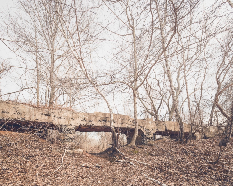
These dormitories are the Farm Colony’s oldest structures.

At the center of Staten Island lies a bucolic expanse of ancient forest, a city-owned amalgam of parks, scout camps, and overgrown lots collectively termed the Greenbelt. It’s an area known for its natural beauty, its murders, and its ruins—on the southern rim, off Brielle Avenue, there’s not one but two historic hospitals that are crumbling to oblivion. The grounds of Sea View Hospital and the New York City Farm Colony may be the most forgotten quarter of the forgotten borough, representing New Yorks’ highest concentration of derelict buildings, with over two dozen scattered through 300 acres of mostly wooded land.

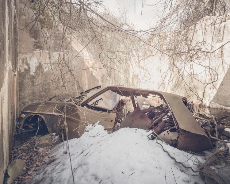
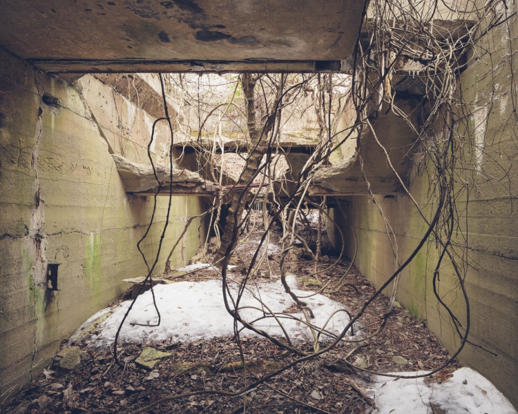
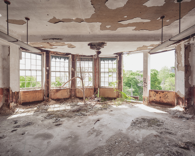
What’s left of the Farm Colony only comes out in the winter—from May to November, thick greenery conceals the battered rubblestone facades of its twelve remaining structures—over forty years of neglect, trees have reclaimed the grounds.  The forest bends when the wind gusts, groaning like a legion of creaky doors.  In areas that had once been cleared for farmland, thorns amass in undulating hillocks, hooking and scoring the flesh of any who dare to trudge through the overgrowth.  Some of the vines have adhered to the ruins of the oldest buildings, whose interiors have almost completely collapsed, leaving only a tangle of splintered beams and nail-studded boards. If you peek through the window of one of these wrecks, there’s a German Expressionist nightmare of canted doorways and lurching walls.

These dormitories replaced the charmless farmhouses of the Richmond County Poor Farm, which had operated on the spot since 1829 to house and rehabilitate New York City’s aging poor.  By the time Staten Island was incorporated as a borough of New York City, the Poor Farm was renamed the Farm Colony.  With distinctive gambrel roofs modeled in the Dutch Colonial Style, the buildings constructed in this period were designed to evoke the ease of rural living, avoiding an institutional design to reflect changing attitudes in the treatment of the poor.

In colonial times, poverty was equated with deviancy, and the care of dependents was traditionally left to the Church, but by the 19th Century, governments across the United States began constructing state-run institutions to house the poor, infirm, mentally ill, and developmentally disabled.  This was the era of the farm colonies, when able-bodied inmates were expected to work in exchange for their room and board.

200 residents could grow enough vegetables to feed 3,000, which was more than enough to share with other institutions across the city, including City Hospital on Blackwell’s Island.  With the construction of several new dormitories in the 30s, the population quickly expanded to over 1,000, and started to exhibit a perplexing problem.  As early as 1910, 75% of the residents were over 50, a quarter over 70, and the majority were unfit for manual labor.

Sweet Home_Farm Colony_9543_1080

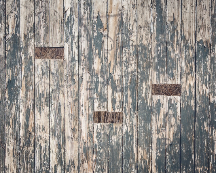
Light sneaks through a boarded window into the close quarters of a former inmate dormitory.

By 1925, farm work was no longer mandatory, but many residents enjoyed the perks of voluntary farming and maintenance jobs.  Tokens could be exchanged for tobacco, pipes, and candy, and those who worked got first priority in the dining hall.  Anecdotes from the simple lives of this isolated community scatter the archives of the New York Times.  Heated horseshoe rivalries, band performances, and handicraft sales were among the most prominent events of a life lived at the Farm Colony.

The Farm Colony was in many ways idyllic, but not without its controversies.  Like all institutions in this period, the facility was guilty of overcrowding at times.  In 1934, a hospitals commissioner was shocked to discover that many of the Colony’s 200 employees were habitually intoxicated, resulting in the resignation of the superintendent and his second in command.  By the 1950s, the facility had become a geriatric hospital.  The second half of the 20th Century marked a steady decline in residency.  Increased prosperity nationwide and the introduction of social security further depleted the population, and the property was abandoned in 1975.

Though the area was designated a historic district in 1985, next to nothing has been done to protect the buildings.  Thought to be hazardous to children playing at a nearby ballfield, a morgue was demolished in 1999, ruffling the feathers of the borough’s preservationists.  The city has been trying to drum up interest in the site over the last decade, briefly considering it as the site of a new police academy, and shortlisting the Farm Colony as a possible location for a school of engineering, but they’ve repeatedly been unable to attract an interested party.  City council member James Oddo, who called the Farm Colony the “bane of his existence”, made another appeal in 2012 for expressions of interest.  Lack of access to mass transit may be partially to blame for the lack of response.  As another piece of Staten Island’s architectural legacy falls to its knees, it serves as a reminder that a bureaucratic designation is less than half the battle.

Cropsey House_Farm Colony_9616_1080

The gambrel roofs of the older buildings hearken back to a period long before their hundred year history.

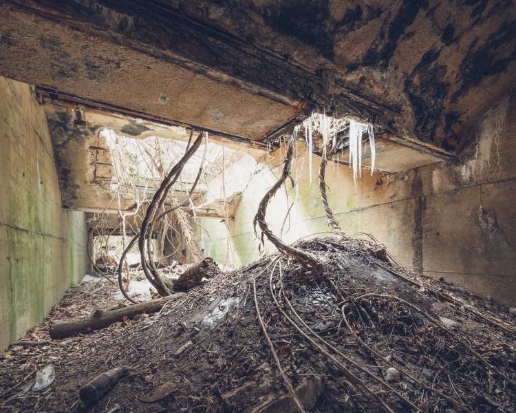
Generations of vandalism have eviscerated the interiors of the Farm Colony’s remaining buildings.  Inside, little has been left to catch the eye.  Floors are strewn with rubble.  Plaster dust accrues in drifts, exposing a patchwork of masonry.  Wintry details complement the desolation—a broken windowpane bearded with icicles, hallways inundated with frozen pools.  Juvenile graffiti covers every surface, except on the ground floors, where the building has been sealed off with cinderblocks in an unsuccessful attempt to keep out intruders.  These corridors are intensely, eerily dark, and all but untraveled.  Featherweight vines dangle from the ceilings of the blackest chambers like some alien weed.  A single breath seems to cloud these rooms with fog, otherwise they’re empty.  To find any artifacts one must head underground.  Barely visible in the basement gloom, piles of old laundry bloom with mold, chairs are devoured by rust.

Take A Seat_1080_IMG_9532

A dank basement room carpeted with coils of wire.

The Farm Colony may be decrepit, but don’t call it desolate.  Even with temperatures below freezing, the grounds experience a weekend rush.  If you plan to visit, be prepared to dodge a few paintballs, it’s one of the most popular pastimes here at the Colony. (Visitors have equipped the grounds with an elaborate field of obstacles pilfered from the buildings.)  Elsewhere, the grounds are littered with all the tokens of a high school hangout.  Beer cans, cigarette stubs, and junk food wrappers pave the walkways.  At night, these lanes are crowded with teenagers, who’ve come to escape their parents and affirm their friendships by way of getting scared.  Fearing boredom above all, they enter the Greenbelt ruins in spite of the warning of a cautionary tale.

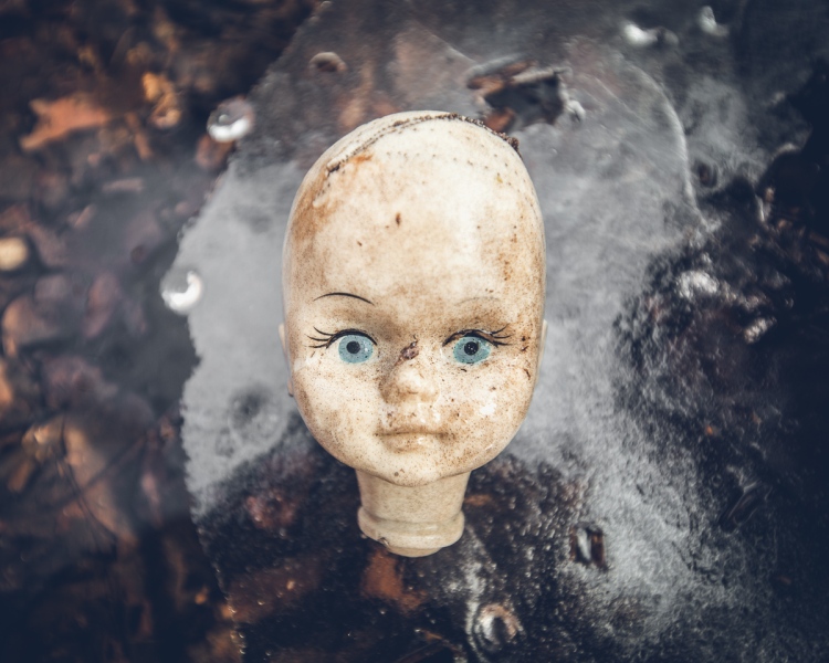
Legends of a serial killer called Cropsey have spread through this part of Staten Island for as long as anyone can remember; it’s a fiction intwined with truth.  The land surrounding the Farm Colony is haunted by a history of real-life horrors, starting in the 1920s with the abduction and murder of a seven-year-old boy, who some had seen walking into the woods with an elderly man on the day of his disappearance. (The crime prompted an investigation of Farm Colony residents and staff, but nothing turned up that could implicate anyone in the crime.)

Later, sinister abuses at the nearby Willowbrook State School for the developmentally disabled cast a pall over the area.  Andre Rand, a former orderly at the facility, is thought to be responsible for a series of child murders that shocked the borough in the 70s and 80s.  Rumor has it he lived in the tunnels under the abandoned hospital, and it’s confirmed that he set up camp on the grounds.  In 1987, the body of Jennifer Shweiger was found buried in a shallow grave not far from his campsite.  Most of Willowbrook was renovated and incorporated into the College of Staten Island in the 1990s.  In the intervening years, the Farm Colony has taken its place in the collective imagination as the site most associated with the Cropsey legend.

The Farm Colony has never been open to the public, but that hasn’t stopped it from becoming a shared space.  Though some would call it useless, ugly, or appalling, the youth of Staten Island has somehow endowed this place with meaning and mystique.  Its value is written in the dust, just count the footprints.  Through fogbanked mornings, orange autumns, and torrid summer nights, the Colony beckons—a wilderness in which to be wild, a victim to bear our destructive instincts, a place to harbor our fears, and face them.

Sunset_Farm Colony_1979_1080

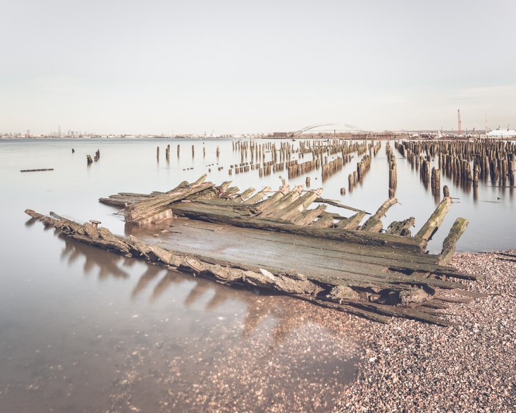
The sun sets on the Farm Colony.

Dining Hall_Farm Colony_9475_1080

Graffiti in the dining hall…

Trashed Hallway_Farm Colony_9487_1080

…and a devastated hallway on the top floor.

Cafeteria_Farm Colony_9518_1080

The gate left open to the laundry and industrial building.

Cafeteria Graffiti_9704_1080

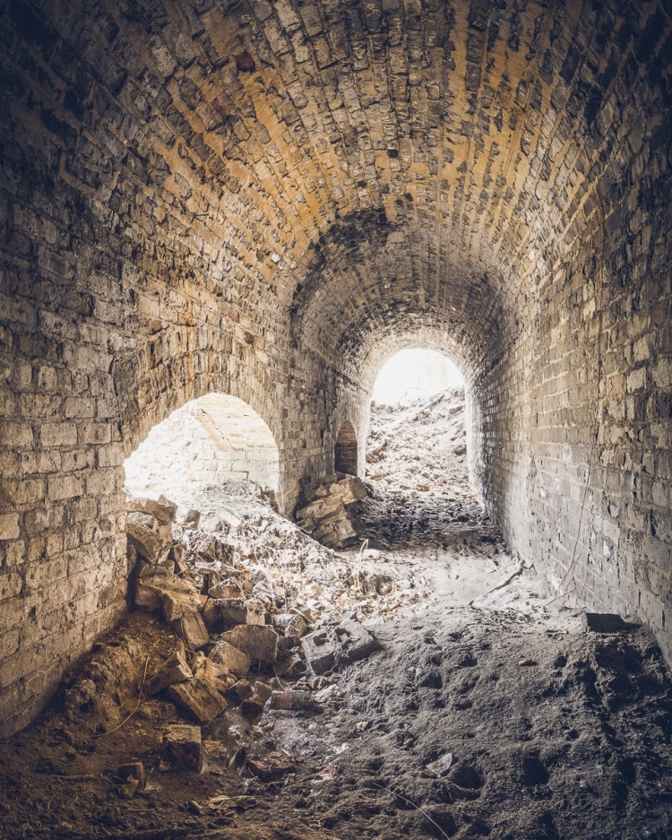
Inside the cavernous industrial building, another popular spot for graffiti.

Nurses Residence_Farm Colony_9645_1080

The unadorned Nurses Residence, once the insane pavilion, sits across from the paintball area.

Stairwell Oculus_Farm Colony_9594_1080

Inside one of the four H-shaped dormitories, a staircase landing strewn with rubble.

Broken Window Light_Farm Colony_9579

Light leaks in a dark chamber.

Dungeon_Farm Colony_9539_1080

Can you identify these vines (or roots) growing in a pitch black basement room?

Laundry Room_Farm Colony_9569_1080

What appears to be a former laundry room, the floor is covered with moldy slippers, blankets, and clothes.

Wrecked Room_Farm Colony_9688_1080

The last room standing in the three oldest dormitories is on the verge of collapse.

For a closer look at the legends surrounding the Farm Colony and the case of Andre Rand, watch the documentary Cropsey, available on Netflix.

For more on New York City’s abandoned institutions, check out Letchworth Village:

Legend Tripping in Letchworth Village

Legend Tripping in Letchworth Village


Wandering Fort Wadsworth

$
0
0
Will Ellis_Abandoned NYC_Fort Wadsworth_Staten Island_01

Battery Weed looms over a desolate shoreline in Fort Wadsworth, Staten Island.

At the easternmost tip of Staten Island, a natural promontory thrusts over the seething Narrows of the New York Harbor, formed by glaciers thousands of years ago. The site’s geography most recently made it a prime location for the Verrazano Bridge, but its history as a popular scenic overlook and strategic defense post dates back to the birth of the nation. The British had occupied the area during the Revolutionary War, and its first permanent structures were built by the state of New York in the early 1800s. These fortifications safeguarded the New York Harbor during the War of 1812, but were abandoned shortly thereafter. So began the familiar cycle of ruin and rebirth that characterizes the history of Fort Wadsworth.

By the mid-19th century, these early structures had fallen into an attractive state of decay. In a time when all of Staten Island held a romantic appeal as an escape from the burgeoning industrialism of New York City, Fort Wadsworth in particular was known for its dramatic terrain, sweeping views of the harbor, and evocative old buildings. Herman Melville described the scene in 1839:

“…on the right hand side of the Narrows as you go out, the land is quite high; and on top of a fine cliff is a great castle or fort, all in ruins, and with trees growing round it… It was a beautiful place, as I remembered it, and very wonderful and romantic, too…On the side away from the water was a green grove of trees, very thick and shady and through this grove, in a sort of twilight you came to an arch in the wall of the fort…and all at once you came out into an open space in the middle of the castle. And there you would see cows grazing…and sheep clambering among the mossy ruins…Yes, the fort was a beautiful, quiet, and charming spot. I should like to build a little cottage in the middle of it, and live there all my life.”

Will Ellis_Abandoned NYC_Fort Wadsworth_Staten Island_02

Under the Verazzano Bridge.

The “castle” was demolished to make way for new fortifications constructed as part of the Third System of American coastal defense, known as Battery Weed and Fort Thompkins today. The batteries remain the fort’s most impressive and unifying structures, but they too were deemed obsolete as early as the 1870s due to advances in weaponry, and were used for little more than storage by the 1890s. At the turn of the 20th century, Fort Wadsworth entered yet another phase of military construction under the Endicott Board, when the United States made a nationwide effort to rethink and rebuild its antiquated coastal defenses. Like its predecessors, the Endicott batteries never saw combat, and were essentially abandoned after World War I.

Will Ellis_Abandoned NYC_Fort Wadsworth_Staten Island_03

Inside a powder room of Battery Catlin.

Will Ellis_Abandoned NYC_Fort Wadsworth_Staten Island_04

A squatter’s unmade bed in the back of the structure.

Though Fort Wadsworth was occupied by the military in various capacities until 1995, its defense structures went unused for most of the 20th century. By the 1980s, woods and invasive vines had covered areas that were once open fields, and Battery Weed was living up to its name, overtaken by mature trees and overgrowth. Since Fort Wadsworth was incorporated into the Gateway National Recreation Area in 1995, its major Third System forts (Battery Weed and Fort Thompkins) have been well maintained and properly secured, and upland housing and support buildings have been occupied by the Coast Guard, Army Reserve, and Park Police. But the headlands still retain an air of abandonment, due in large part to the condition of the Endicott Batteries, which remain off-limits to the public.

Will Ellis_Abandoned NYC_Fort Wadsworth_Staten Island_05

Over five of these batteries are scattered across the grounds, all in various states of disrepair.

Will Ellis_Abandoned NYC_Fort Wadsworth_Staten Island_07

The Endicott Batteries are filled with narrow, windowless rooms, tomblike hollows, and underground shafts.

Will Ellis_Abandoned NYC_Fort Wadsworth_Staten Island_08

Their military blandness stands out in contrast to the grace and grandeur of the fort’s earlier structures deemed worthy of preservation.

Layers of history peel back like an onion at Fort Wadsworth, as evidenced by a new discovery just unearthed by Hurricane Sandy. The storm caused a section of a cliff to collapse, downing several large trees and exposing the entrance to a previously unknown battery. Its vaulted granite construction places it firmly in the Third System, which means it was built around the time of the Civil War. Very little is known about the structure, except that it’s the only one of its kind at Fort Wadsworth. My best guess traces its partial construction to the 1870s, when Congress left many casemated fortifications unfinished by refusing to grant additional funding.

Will Ellis_Abandoned NYC_Fort Wadsworth_Staten Island_09

A previously unknown granite battery, possibly dating back to the Civil War, was unearthed by Hurricane Sandy.

Will Ellis_Abandoned NYC_Fort Wadsworth_Staten Island_12

Large mounds of soil block the interior of the battery from view.

Will Ellis_Abandoned NYC_Fort Wadsworth_Staten Island_13

They’d been sifted through ventilation shafts in the ceiling over decades of burial.

Will Ellis_Abandoned NYC_Fort Wadsworth_Staten Island_14

Over the mound, the vaulted structure leads deeper into the ground.

To my disappointment, the next room came to a dead end, and to my horror, it was crawling with hundreds of cave crickets. These blind half spider/half cricket monstrosities pass their time in the darkest, dampest, most inhospitable environments, and are known for devouring their own legs when they’re hungry. They give perspective to the level of isolation of this chamber, which likely stood underground for over a century.

What other mysteries still lie buried in the lunging cliffs of Fort Wadsworth, or the depths of this forgotten battery? The dirt may well conceal deeper rooms and darker discoveries…

Will Ellis_Abandoned NYC_Fort Wadsworth_Staten Island_15

Cave crickets in the deepest room of the forgotten battery.

Special thanks to Johnnie for the tip! Get in touch if you know of a historic, abandoned, or mysterious location in the five boroughs that’s worth exploring.

For more of New York’s neglected military sites, check out Fort Totten:

Fort Totten

Fort Totten


Last Days of the Staten Island Farm Colony

$
0
0
Eerie ruins of the Staten Island Farm Colony

A ruined Farm Colony dormitory seen through the trees.

Part of what makes abandoned buildings so captivating is that their existence is ephemeral, they cannot remain decayed and crumbling forever, and inevitably that means saying goodbye.

Admittedly, the Staten Island Farm Colony is not one of the most spectacular places I’ve seen, (the interiors have been completely destroyed by vandalism) but it remains the one place I’ve come back to more than any other. What’s always impressed me about it is its changeability. The place is reborn with every season, and I suppose that’s true of all abandoned buildings, but I’m always struck by it at the Farm Colony. In the height of summer, its jungle-like atmosphere lends it the look of a fallen Aztec empire, which is almost unrecognizable in the cooler months. It’s haunting in the fall when the fog rolls in, and desolate in the winter when ice and snow blanket the buildings inside and out. Through 40 years of abandonment, the Farm Colony is as ever-changing as the natural world that engulfs it, but it’s looking more and more definite that this historic district will be undergoing a final, permanent transformation in the days ahead.

The Farm Colony’s existing structures.

New renderings for the “Landmark Colony,” with several buildings preserved.

Last month, the Landmarks Preservation Commission unanimously approved a proposal to bring 350 units of senior housing to the site, part of a large new development called “The Landmark Colony.”  In the process, the institution is returning to its historic function as a home for the elderly after a four decade hiatus. (The place was essentially a geriatric hospital when it closed down in the 1970s, though it had been established in the mid 19th century as a refuge for the poor.)  With five buildings saved and one kept as a stabilized ruin, the design will preserve much of the area’s architectural character. The remaining structures will be demolished and replaced with modern residential units, which is to be expected considering just how far gone some of these buildings are.

Several of the places I’ve photographed in the last few years have been set aside for renovation (The Domino Sugar Refinery, the Gowanus Batcave, and P.S. 186 to name a few.)  The Smith Infirmary, the old Machpelah Cemetery office, and most troublingly, the Harlem Renaissance Ballroom have not been so lucky.  It’s rare and encouraging when a structure is fortunate enough to get a second chance in this rapidly evolving city, but as positive as these changes are for their communities, a part of me still feels like something is lost.  I know I’m not the only one who’ll miss the Farm Colony and its embattled ruins, which have become a popular spot for paintballers and Staten Island teenagers to pass the time.

Here’s a series of photos I’ve taken over the last year in sweltering heat, biting cold, snow, rain, and fog. Hopefully I make it back one last time before these ancient grounds are covered with fresh paint and brimming with active retirees year-round.

ABANDONEDNYC_WILL ELLIS_FARM COLONY-14

The Laundry and Industrial building will be preserved…

ABANDONEDNYC_WILL ELLIS_FARM COLONY-13

…As will the Dining Hall. These are the two largest open spaces in the Farm Colony.

ABANDONED NYC_Will Ellis_Farm Colony-2

Daylight trickles into a dark room adjacent to the cafeteria.

ABANDONED NYC_Will Ellis_Farm Colony-11

An arched walkway on a lower floor is a rare example of architectural ornament.

ABANDONED NYC_Will Ellis_Farm Colony-9

The Farm Colony’s most picturesque building is sadly slated for demolition.

ABANDONED NYC_Will Ellis_Farm Colony-12

But a similar dormitory on the south side of the grounds will be stabilized and preserved as a ruin.

ABANDONED NYC_Will Ellis_Farm Colony-5

Snow piles up after winter storms, turning to ice when the temperature fluctuates.

ABANDONED NYC_Will Ellis_Farm Colony-3

A wintry bathroom.

ABANDONED NYC_Will Ellis_Farm Colony-4

This bed is one of the only remaining artifacts from the institution’s past.

ABANDONED NYC_Will Ellis_Farm Colony-10

Trees silhouetted against the clouds, projected through a camera obscura on the ground floor of a residence hall.


Now, if you’ll allow me to make a brief sales pitch…


Get an in-depth history of the Farm Colony in my upcoming book


Abandoned NYC is packed with 150 full-color photographs of sixteen of New York’s most beautiful and mysterious abandoned spaces, including several you haven’t seen on the blog, along with new images and updated essays from many of your favorites. I’ve kept this quiet up until now and I’m so excited to share it with all of you!  Stay tuned for signings and events in February.


Free Print when you order through this link!


Murder in Mariner’s Marsh

$
0
0
Abandoned car in a pit

Mariner’s Marsh, on Staten Island’s North Shore.

At a bend in Staten Island’s North Shore where the Arthur Kill gives way to the Kill van Kull, there’s a strange, desolate landscape that’s equal parts industrial wasteland and pristine wilderness.  Here, an array of factories and freight lines are enveloped by a network of streams, swamps, ponds, and salt marshes, with place names like “Howland Hook” and “Old Place Creek” that wouldn’t feel out of place in a pirate story.

Mariner’s Marsh makes up 107 acres of the area, buffering a dense residential neighborhood from the sprawling New York Container Terminal with a wide expanse of green. Having endured a brief period of industrial use followed by 75 years of abandonment, the resulting wilderness is characterized by the vine-covered relics of factories that thrived on the spot 100 years ago. Even the Parks Department’s official signage describes the landscape as “eerie.” But the text rightfully avoids its darkest chapter, when in 1976 the tragic final act of a forbidden teenage love affair played out among the ruins of Mariner’s Marsh.

Ruin Bridge

A trail leads walkers under an old concrete structure.

The ruins date back to the early 20th century, when the land was occupied by the Milliken Brother’s Structural Iron Works.  Later, the foundry was converted to Downey’s Shipyard, which manufactured war ships, among other vessels.  The factories closed down in the 1940s and have sat abandoned to this day. Wood components of the buildings have completely rotted away, but concrete pylons, pits, and passages remain.  As the buildings deteriorated, the landscape transformed. Today, the former shipyard’s ten man-made basins function as reedy freshwater ponds. Elsewhere, the topography varies from pine and poplar forests to vine-gnarled swamps where wildlife and rare plants thrive.

Bird Blind

A weathered birdwatching blind.

Doll Head

The requisite creepy doll head.

Mariner’s Marsh was acquired by the Parks Department in 1997, but it’s been “closed to the public during environmental investigation” for nearly a decade.  The investigation in question took place in 2006 under the direction of the EPA, which found that a small area of the park contained a high concentration of hazardous materials stemming from its industrial age. Though it appears that some work has been done on the spot, it’s not clear when the park will reopen.  In the meantime, warning signs haven’t stopped neighbors and dedicated bird watchers from enjoying it.  Trails are well-defined and the area is relatively free of garbage, despite the presence of some larger debris.  The east side of Downey Pond is dotted with abandoned hot rods from another era.

Vine Car

One of the park’s many abandoned cars.

Marooned in the marsh

An overturned vehicle marooned in a swamp east of Downey Pond.

Long before Staten Island’s industrial boom, the Lenape Indians camped here to take advantage of the nearby wetlands, where shellfish were plentiful.  Remnants of the wetlands are still visible across Forest Avenue in Arlington Marsh, which is home to some of the last stretches of healthy salt marsh in New York City.  Acquiring it was a major coup for the Parks Department, which plans to keep the 55 acres wild. Here, ghostly remnants of long-forgotten piers and burned out vessels seem oddly in sync with the tidal rhythms of the natural world. At low tide, a boat graveyard comes to the surface in an adjacent cove, where native cordgrass and mussel beds take root in the old hulls of 19th century sailing ships.

Arlington Marsh

An expanse of pilings that once supported massive factory docks.

Oyster Beds

Oyster beds in the hull of a long-abandoned ship.

Old Ship

Fragment of a sailboat at Arlington Marsh.

This post would’ve ended there if I hadn’t come upon a mention of the 1976 murder of Susan Jacobson in connection with the area. Though the scene of the crime is never referred to as Mariner’s Marsh, the description is unmistakable in a New York Times article published in 2011, which begins:

“The 16-year-old boy had settled on a plan on how to kill his girlfriend. There was a blighted section on the north shore of Staten Island called Port Ivory, overgrown coastline facing the industrial banks of New Jersey. The land was pocked with holes leading to small underground rooms, like bunkers.

This abandoned lot was the last thing a 14-year-old girl named Susan Jacobson ever saw as she climbed down into one of those holes with her boyfriend, Dempsey Hawkins, on May 15, 1976. “

In the ruins

Ruins of a system of rails that closely match a description of the murder site.

Included in the article is a scan of a handwritten letter from Hawkins to the reporter in which he details an idyllic romance with Jacobson that ends abruptly following an abortion. In the final paragraph, he goes on, “In came 1976 and the insanity and the whole painful mess I am about to relate succinctly simply because it’s disturbing.  I strangled Susan and concealed her body in a metal barrel in a wooded area across from a Proctor and Gamble factory on Staten Island.

Two years passed before her remains were discovered by a boy playing in the tunnels. He had assumed they were dog bones until a friend spotted Susan’s tennis shoes. Hawkins, now 55, was denied parole for the eighth time in 2012 despite a history of good behavior behind bars. Parole commissioners have repeatedly taken issue with what occurred immediately after the crime. On multiple occasions, Hawkins himself participated in search parties for the missing girl, knowing all the while precisely where the body was hidden.

Vines

Icicles stretch into the darkness of the tunnel as vines spiral toward the light.

The tunnel

An arched passageway near the scene of the crime. 


Book-Related Events Coming Up:

  • Brooklyn Brainery, April 15th 8:30-10:00, $7 (Sold Out)
  • Dead Horse Bay, May 2nd, @ 12:45 I’ll be leading a walking tour of one of my favorite places in NYC with Untapped Cities
  • Mid-Manhattan Library, May 7th, 6:30-8:00 PM, Free!


Dredging the Archives + May 7th Library Lecture

$
0
0
Will Ellis_Abandoned NYC-1-3

The spooky Walloomsac Inn in Benington, VT is actually occupied as a private residence.

On Thursday, May 7th at 6:30 PM I’ll be presenting at the Mid-Manhattan Branch of the New York Public Library as part of their Author @ the Library series.  This will be the last book talk I’m giving for a while, so if you’ve missed out on past events and would like to attend, now is the time.  The best part is it’s totally free, open to the public, and there’s no need to register or buy a ticket.  Head here for more info.

Since its release at the end of January, the book has gotten a great response, particularly on the world wide web.  For the highlights, check out these bits in The New York Times, Wired, Complex, and Slate, who toured the Jumping Jack Pump House with me and captured it on video back in March.

I have some exciting posts in the works for you, but for now I wanted to share some images from the archive that haven’t been shown here before–places that didn’t warrant a full post for one reason or another, often because I couldn’t get inside, didn’t have time to poke around, or there just wasn’t a lot to see. Some of them are quite interesting nonetheless. Enjoy!

Will Ellis_Abandoned NYC-3

A striking abandoned house in Searsport, Maine.

Will Ellis_Abandoned NYC-1-4

Sea View Hospital, Staten Island.

Will Ellis_Abandoned NYC-4

La Guardia Men’s Shelter in Chester, New York…

Will Ellis_Abandoned NYC-9

…plenty of peeling paint inside, but not much else.

Will Ellis_Abandoned NYC-5

Ruined house in the Hudson Valley.

Will Ellis_Abandoned NYC-8

Raccoon peering into an abandoned asylum ward at Kings Park, LI.

Abandoned natural gas silos in Rossville, Staten Island.

These mammoth LNG storage tanks in Rossville, SI were abandoned immediately after construction.

Abandoned motel near Yosemite National Park.

Ghost motel near Yosemite National Park.

San Francisco's Fort Point. (not abandoned)

San Francisco’s Fort Point. (not abandoned)

Abandoned house in Queens.

An abandoned house in Queens, now demolished.

Brooklyn Navy Yard

A well-preserved surgeon’s residence at the Brooklyn Navy Yard Hospital.

Will Ellis_Abandoned NYC-6

An abandoned carriage house in Newport, RI locals call “the Bells.”


The Sea View Children’s Hospital

$
0
0
Forested views from a lower floor day room at Seaview Children's Hospital.

Forested views from a lower floor day room at Sea View Children’s Hospital.

At the turn of the twentieth century, tuberculosis was the second leading cause of death in the city and a major world health concern known to disproportionately affect the urban poor. In New York City, two-thirds of the 30,000 afflicted were dependent on city agencies for treatment. Growing concern from charitable organizations spurred the establishment of New York’s first public hospital designed exclusively to treat tuberculosis, care for the “sick, poor, and friendless,” and keep the epidemic under some measure of control by isolating sufferers from general hospitals.

If you were diagnosed with tuberculosis in the early 1900s, your prognosis was grim. Lacking a cure, the only treatments thought to ease symptoms were fresh air, rest, sunshine, and good nutrition. A pleasant view was also considered essential for staving off depression. For this reason, hospital planners settled on a privately owned 25-acre hilltop parcel in rural Staten Island called “Ocean View,” just across from the already established New York City Farm Colony. The plot was surrounded by a vast expanse of forested land (known as the Greenbelt today) which enabled the hospital grounds to expand as necessary.

When Sea View Hospital was dedicated on November 12, 1913, the New York Times called it “the largest and finest hospital ever built for the care and treatment of those who suffer from tuberculosis.” The Commissioner of Public Charities claimed it was “a magnificent institution that is vast, ingenious, practical, convenient, sanitary, and beautiful, the greatest hospital ever planned in the world wide fight against the “white plague.”  Though the new facilities effectively eased the suffering of tuberculosis patients and provided housing for the poor, little could be done to actually save lives in the long term. Most eventually succumbed to the disease.

A sapling takes root in the light-filled solarium on the top floor.

Saplings take root in a light-filled solarium on the top floor. (Prints Available)

Two window fixtures had vanished.

Two window fixtures had vanished, offering an unobstructed view of the surrounding woodlands.

Doorway into the open-air pavilions.

Doorway into an open-air pavilion.

Hospital beds, cribs, and equipment left behind in a day room on a lower floor.

Hospital beds, cribs, and equipment left behind in a day room on a lower floor. (Prints Available)

In 1943, the development of the antibiotic streptomycin at Rutgers University led to a series of breakthroughs in the treatment of tuberculosis over the next decade, and much of that research took place at Sea View Hospital.  The enthusiasm over these dramatic developments is captured in a 1952 report by the Department of Hospitals: “Euphoria swept Seaview Hospital.  Patients consigned to death at the hands of the White Plague celebrated a new lease on life by dancing in the halls.”  The transition was swift. By 1961, Sea View’s pavilions were practically emptied as patients miraculously recovered as a result of the new therapies.

Today, a long-term care facility operates in several of the buildings and some structures have been repurposed by community agencies and civic groups, but much of the Sea View Hospital campus lies abandoned. Past a fenced enclosure delineating the active section of the hospital, the grounds give way to the bramble-choked wilds of the Staten Island Greenbelt. The creepy ruins of the old women’s pavilions situated on the northern border are a popular detour on hikes from the neighboring boy scout camp.

To the east lies the imposing Children’s Hospital, completed in 1938 and abandoned in 1974.  Its spacious, window-lined solariums are typical of earlier Sea View wards, flanked on either side by open-air porches which were occupied by recovering patients 24 hours a day during the height of the epidemic. In an otherwise clinical Landmarks Preservation Commission report published in 1985, the researcher notes that “the building rises from a deep slope… Wooded surroundings, particularly dense to the east and south of the building, enhance the sense of isolation.”  The view he’s describing is indeed one of New York City’s most surreal (pictured below in 2012).

My first view of the hospital three years ago,

The ominous Children’s Hospital, seen from a hilltop on the grounds of Sea View Hospital.

Reuse of the structure seems extremely unlikely given the large number of abandoned buildings within the active hospital complex that would make better candidates for restoration.  Area conservationists are fighting to keep the surrounding woodlands protected from developers by making it a permanent part of the Greenbelt network of natural areas, and the building itself is nominally protected from demolition as part of Sea View Hospital’s historic district designation.

That doesn’t mean that the building won’t serve a purpose as it continues to crumble.  As I’ve mentioned in previous posts, Staten Island teenagers have a long history of voraciously exploring (and vandalizing) their local ruins. With the renovation of the Willowbrook State School in the 1990s, the later demolition of the Staten Island Monastery, and the impending restoration of the New York City Farm Colony, the isolated, under-the-radar Children’s Hospital may be next in line as the site of that requisite rite of passage. Only time will tell.

Passageway to the hospital wing.

There’s little to suggest the building was used exclusively as a children’s hospital in its last years of operation.

Restrooms had windows for observation.

Even the restrooms had windows for observation.

Drifts of plaster piled up near the dark room.

Drifts of plaster pile up on a table outside the darkroom.

An abandoned hospital staple--the upright piano.

The upright piano, an abandoned hospital staple.

“Dixie Cup for Dentures.” The name says it all.

A utility room in the attic held lockers and supplies, mostly empty.

A storage room in the attic had been pillaged.

A steep staircase lead to the upper reaches of the utility floors.

A steep staircase led to the upper reaches of the utility floors.

Lowers floors were boarded up, which always allows for the eeriest light.

Lowers floors were boarded up, which always allows for the eeriest light. (Prints Available)

The last room I came to was the most surprising--a dayroom piled with several feet of hospital records, files, and audio tapes.

The last room I came to was the most surprising–a boarded-up dayroom piled several feet high with hospital records.


9781580934282IN OTHER NEWS… my friend Oriana Leckert‘s book “Brooklyn Spaces” is out this week.  We’re a bit like kindred spirits, Oriana and I, but she goes more for the crowded, lively, and creative than the empty, eerie, and decrepit.

The (50!) places profiled in the book show the authentic, human side of the global phenomenon that is “Brooklyn cool,” highlighting the heartfelt endeavors of a wave of culture makers that migrated to the borough for cheap rent and fashioned a network of bustling performance venues, art enclaves, and meeting places out of Brooklyn’s post-industrial landscape.  Her obvious passion for offbeat museums, community gardens, communal living spaces, and out-there artist residencies is beyond infectious.

Do yourself a favor and pick up a copy! And head to what I’m sure will be a raucous, sweaty launch party on May 30th.


Port Reading’s McMyler Coal Dumper

$
0
0
Abandoned NYC_McMyler Coal Dumper_Will Ellis-1-3

The abandoned McMyler Coal Dumper in Port Reading, NJ

There’s a stretch of the Arthur Kill between Rossville, Staten Island and Port Reading, New Jersey that’s something of an abandoned wonderland.  From the New Jersey side, the horizon is dominated by the twin natural gas tanks of Chemical Lane, and the famous Staten Island Boat Graveyard is plainly visible just across the water.  But towering over the scene is a structure that rivals both with its staggering beauty and power—the McMyler Coal Dumper.

Actually, it would be more accurate to call it a McMyler Coal Dumper. It was one of many nearly identical structures built on the shores of the New York Harbor in the early-to-mid 20th century, including two on Pier 18 in Jersey City. But the Port Reading site is notable for being the last one standing in the New York area. It was constructed in 1917, making it 99 years old at the time of this post.

mcmyleradcover

A 1957 ad for Pier 18 in Jersey City, which boasted two “Big Mac” McMyler Dumpers.

In a vast regional network of coal mines, breakers, railroads, and manufacturing hubs, these machines provided a vital link that helped fuel New York’s industrial age, transferring massive amounts of coal brought by rail from Pennsylvania and the Alleghenies into ships entering the harbor.  A McMyler Dumper could unload a 72-ton car of coal every two and a half minutes, operating on a continuous loop for maximum efficiency.

Upon entering the pier, railroad “hoppers” carrying a full load of coal would be pushed up a ramp with a mechanism called a barney. Once in position at the base of the tower, the entire car and its contents would be lifted up on an unloading platform and tilted at 120 degrees, spilling the coal into an enormous “pan,” which funneled the material through an unloader chute and into the holds of outgoing barges. Once empty, the car would be lowered and pushed onto a kickback trestle by the next car in the line-up.  These rails looked very much like a roller coaster, and they worked in a similar fashion, using the power of gravity to propel empty cars off of the pier and into the rail yards beyond. The contraption required twelve men to operate, and the work was risky. The brute force of the machine claimed many lives and limbs over the years.

Abandoned NYC_McMyler Coal Dumper_Will Ellis-10

A braver soul would have climbed the tower, but I was satisfied with the view from the pier.

The design stood the test of time, and the pier operated for over 60 years with nearly uninterrupted use (a fire caused considerable damage in 1951, but the unloader was quickly rebuilt.) With demand for coal declining, the machine dumped its last load in the early 80s, and has been steadily deteriorating ever since. Though there has been interest in designating the structure an historic site, its location on private property in an active industrial area has made it an unlikely candidate, and the cost of restoring or moving the structure would be prohibitive, to put it mildly.  Unless new industrial development threatens the site, it will likely remain a picturesque ruin for another century before eventually collapsing into the Kill and vanishing into the muck.

That is lucky for the throng of Canada Geese who’ve made a surreal home out of the hulking relic.  Though they’re nice to look at, I’ve never had a pleasant encounter with these creatures, and have been charged at by enough of them on the remote shores of the outer boroughs to know they mean business.  This time around they were content to squawk and hiss their disapproval from a distance, but I would advise everyone to stay far away during nesting season, which is right around the corner.

Abandoned NYC_McMyler Coal Dumper_Will Ellis-9

The self-appointed guardians of the coal dumper.

Abandoned NYC_McMyler Coal Dumper_Will Ellis-6

A pair of steam engines inside the machine room powered a cable drum…

Abandoned NYC_McMyler Coal Dumper_Will Ellis-5

…which controlled the “barney,” a mechanism used to push cars onto the unloading platform.

Abandoned NYC_McMyler Coal Dumper_Will Ellis-7

These cable drums raised and lowered the unloading platform.  Much of the machinery has been removed by scrappers over the years.

Abandoned NYC_McMyler Coal Dumper_Will Ellis-8

The place has a fair amount of graffiti, some quite old. Kaleen’s protestation on the upper right was particularly endearing.

Abandoned NYC_McMyler Coal Dumper_Will Ellis-3

A derelict ferry boat sinks into the Kill on an adjacent pier.

Abandoned NYC_McMyler Coal Dumper_Will Ellis-4

The pan and chute, pictured here, were left in an upright position until Hurricane Irene sent them crashing onto the pier below in 2011.  An operator would have sat in the little chamber on the right. A pair of abandoned gas tanks in Rossville, Staten Island can be seen on the horizon.

Abandoned NYC_McMyler Coal Dumper_Will Ellis-2

Low Tide at the McMyler Coal Dumper.

You can see (a model of) a McMyler Coal Dumper in action in the following video:


Approaching the “Forgotten Borough”

$
0
0
Staten Island Ferry

Seagulls follow in the wake of the Staten Island Ferry.

Hello friends, its been a while. I’ve been on a bit of a hiatus from poking around abandoned buildings, but I’m back now with something a little different. This is the first installment of a series on Staten Island—an area of the city that tends to go unnoticed, but is very much worth exploring.

For the unfamiliar, Staten Island stands with Manhattan, Brooklyn, the Bronx, and Queens as one of the five boroughs that make up the city of New York. It is the third largest and least populated of the five. Its identity has always been somewhat distinct from the city at large, due in part to its geographical isolation. Prior to the construction of the Verrazano Bridge in 1964, no crossing existed between Staten Island and any other borough. It remains something of an outlier today, with a suburban nature and right-leaning political tilt. A record of neglect from city government has earned it the oft-repeated title “the forgotten borough,” and the name has stuck.

abandoned-nyc_arthur-kill-road_staten-island-forgotten-borough-2

The Staten Island Ferry departs from Lower Manhattan.

From a Manhattan-centric point of view, a trip to Staten Island begins with a ride on the Staten Island Ferry. Over 21 million passengers embark on the 25-minute journey from Lower Manhattan to St. George each year. With dramatic views of the Statue of Liberty and the surrounding harbor, it’s a well-known attraction for New York City tourists. The ride is offered free of charge by the city’s Department of Transportation, but that hasn’t always been the case.

hw1871p737628

An engraving of the 1871 “Westfield” disaster.

Back in the 18th century, sailboats manned by private individuals competed for fares between Manhattan and Staten Island.  In 1817, the first mechanically powered ferry service went into operation, under the direction of Captain John de Forest of the Richmond Turnpike Company. His brother-in-law Cornelius Vanderbilt took over in 1838. Existing ferry service proved inadequate as Staten Island developed, and accidents were common.

In 1871, a boiler explosion on one of the ferries claimed the lives of more than 85 passengers. Jacob Vanderbilt, the president of the Staten Island Railway at the time, was charged with murder, but never convicted. In 1901, a ferry operated by the Staten Island Rapid Transit Company collided with a Jersey Central ferry and sank into the harbor soon after departing the port at Whitehall. Though the disaster was far less deadly than the 1871 episode, city authorities used it as justification to seize control of the service by 1905.

abandoned-nyc_staten-island_arthur-kill-road_approaching-staten-island-3

The iconic orange color of the ferries was adopted in 1926, to increase their visibility in heavy fog and snow.

abandoned-nyc_staten-island_arthur-kill-road_approaching-staten-island-4

Leaving Manhattan.

A nickel fare was the rule through most of the 20th century, but was increased in 1975 to a quarter, and in 1990 to 50 cents, causing an uproar among borough residents. Coupled with mounting grievances over the Fresh Kills Landfill on the island’s west shore, the fare hike gave rise to a secession movement, which culminated in the passage of a non-binding referendum to make Staten Island an independent city in 1993.

Efforts to secede were subdued by the election of Mayor Rudy Guiliani, who rode to power due in part to overwhelming support from Staten Island voters, many of whom had been won over by his promises to close the landfill and do away with the fare. He followed through on both, abolishing the fare in 1997 and closing the landfill in 2001.

abandoned-nyc_staten-island_arthur-kill-road_approaching-staten-island-5

The Verrazano Bridge was the longest suspension bridge in the world at the time it was built.

While the ferry has played a significant role in the history of Staten Island, the construction of the Verrazano-Narrows Bridge has arguably had the greatest impact on its development. The story of Staten Island can generally be understood in terms of two epochs—before and after November 21, 1964, the day the bridge first opened to traffic.

Long-time residents speak longingly of Staten Island before the bridge—when country roads meandered through sweeping forests, quiet beach communities, and open expanses of farmland crawling with nanny goats. In the 19th century, full-time islanders lived side by side with some of the city’s wealthiest residents. As the industrialized city minted new millionaires, many of them looked to the rolling green hills of Staten Island as a scenic escape.

The nature of the borough was permanently altered as the Verrazano-Narrows Bridge prompted a mass migration of newcomers from overpopulated Brooklyn. The influx covered farms and forests with mile upon mile of tract housing, plaguing the island with traffic problems that persist to this day.

abandoned-nyc_staten-island_arthur-kill-road_approaching-staten-island-7

The official name of the Verrazano-Narrows Bridge includes a misspelling of its namesake, Florentine explorer Giovanni da Verrazzano.

As much as the borough has transformed over the years, it has retained its essential otherness. Crossing the harbor by ferry or bridge signals a psychological detachment from the urban environment of New York as we know it. In the hum of traffic, or the roar of surf, the city melts away and you enter a new frontier. Beyond and in-between the strip malls and cookie-cutter houses, scattered remnants of an older, more pastoral Staten Island await. There, Times Square feels a million miles away.

Over a series of upcoming posts, I’ll be examining the many artifacts and oddities that litter the far-flung edges of the borough, and sharing the history behind them. In the meantime, you can visit my website to see more photos from the project, “Arthur Kill Road.”

abandoned-nyc_arthur-kill-road_staten-island-forgotten-borough-6

View of Staten Island obscured by fog, from Bay Ridge, Brooklyn.

abandoned-nyc_arthur-kill-road_staten-island-forgotten-borough-7

An early morning at Fort Wadsworth, on the opposite side of the span.


Scouring the “South Pole” of New York

$
0
0
Outerbridge Crossing

Rotted pilings beneath Outerbridge Crossing, with views of Perth Amboy, NJ.

From St. George, ride the Staten Island Railroad to the end of the line and you’re only a short walk from the southernmost point in New York State, at the mouth of the Arthur Kill. The name of the waterway stirs the imagination, but its Dutch origins are benign. Achter kill means back river or channel, in reference to its location at the “back” of Staten Island. Intriguingly, the route was carved out by an ancestral iteration of the Hudson River. Glacial activity altered the course to its current position, but the vestigial strait remained, isolating a sneaker-shaped land mass. Staten Island was born.

conference-house

The Conference House

A stone’s throw from the so-called “south pole” of New York State, there’s an impressive bit of Revolutionary War history known as The Conference House. The name refers to a peace conference held there on September 11, 1776 between British commander Lord Howe and representatives of the Continental Congress, Benjamin Franklin and John Adams among them. Over the course of the three hour meeting, Howe urged the men to put aside their little rebellion. (They declined to do so.)

True to its contrarian nature even in revolutionary times, the borough was a loyalist stronghold, warmly greeting British troops upon their arrival. Hundreds of islanders enlisted in the British army as the conflict escalated. George Washington himself called the Staten Islanders “our most inveterate enemies.” John Adams was less generous, labeling them “an ignorant, cowardly pack of scoundrels, whose numbers are small, and their spirit less.

abandoned-nyc_staten-island_arthur-kill-road_outerbridge-crossing_charleston-2

Low tide in the Arthur Kill reveals the remains of wooden ships.

abandoned-nyc_staten-island_arthur-kill-road_outerbridge-crossing_charleston-3

The borough is home to several lesser-known “boat graveyards” in addition to the famous Rossville salvage yard.

Tracing the Arthur Kill past the quaint historic houses of Tottenville, we enter into wilder territory and arrive at the base of Outerbridge Crossing, which spans the Arthur Kill between Charleston, SI and Perth Amboy, NJ. New Yorkers could be forgiven for assuming the name refers to its status as the most remote bridge in New York City, but it’s actually named for Eugenius Harvey Outerbridge, the first chairman of the Port Authority of New York and a resident of the borough. “Outerbridge Bridge” wouldn’t do, so they deemed it a “Crossing.”

Wandering these regions can be treacherous if you don’t plan ahead. As the tide ebbs and flows, open shoreline gives way to mud and water, leaving you with no way out but the head-high reeds of the marsh. In nesting season, geese are liable to attack (speaking from experience here). But for those willing to brave the wilderness, there are rewards. The fabric of the city dissolves on the outermost edges of Staten Island, and the ground is a layer cake of archaeological finds.

abandoned-nyc_staten-island_arthur-kill-road_outerbridge-crossing_charleston-4

The remains of the Atlantic Terra Cotta Company factory line the shores of the Arthur Kill at the end of Ellis Street.

One area of interest at the foot of Ellis Street marks the site of The Atlantic Terra Cotta Company, which made colorful architectural ornaments for many notable city buildings, including the Flatiron and the Woolworth. It closed down in the 1940s and was demolished soon after, but much of the old factory is still there in the form of rubble.  Enterprising beachcombers can still find Atlantic Terra Cotta tiles if they hunt long enough. (The old adage “leave no stone unturned” applies here, as many of the most intricate pieces are one-sided.) I managed to find a beautiful acorn-themed tile with an ATLANTIC stamp, but plain bricks were more readily available.

Many of them are inscribed with the names of long-gone manufacturers, resembling fragments of time-worn tombstones. Thanks to these markings and a devoted online community of brick collectors, it’s a simple matter to pinpoint their origins. The “RICHMOND” and “ATLANTIC” bricks were made in Staten Island, but others trace their ancestry to Brooklyn or New Jersey. Some are from much farther afield—“RELIANCE” Bricks hail from Texas; “MO REX” from a town called Mexico, Missouri. How all of them ended up here is a bit of a masonry mystery.

abandoned-nyc_staten-island_arthur-kill-road_outerbridge-crossing_charleston-5

Manufacturer’s marks on the bricks point to a wide range of origins.

Just inland, marshes give way to roving woodlands that hold secrets of their own. If you look into any patch of untended forest, and many of the front yards, you’ll find a wealth of rusty relics of the one man’s treasure variety. While there isn’t much history to glean from them, they are fascinating to look at. A natural area known as Sharrot’s Shoreline was once filled with mountains of scrap metal and scores of abandoned cars. Only a few remain today after cleanup efforts by the city. What’s left is a serene nature reserve that would thrill most bird-watchers, though they might have a hard time finding a way in.

Nearby, a deserted graveyard of auto parts marked one of my most surprising finds to date. Chief among the relics was a group of corroded buses, apparently from the 1960’s. While the scene has an ancient air, the plot was the site of a multi-generational family business until quite recently, according to a neighbor who gave me a stern warning for trespassing on private property. (For that reason, I wouldn’t advise seeking them out for yourself.)

This has been the second installment of a series of posts on the edges of Staten Island. Next up, we’ll continue our trip down Arthur Kill Road, delving deeper into the history of Charleston and the “haunted” Kreischer Mansion.  See more photos from the project here.

abandoned-nyc_staten-island_arthur-kill-road_outerbridge-crossing_charleston-8

A foot of snow covers a “graveyard” of auto parts…

abandoned-nyc_staten-island_arthur-kill-road_outerbridge-crossing_charleston-9

..pictured here in the fall.


Ghosts of Kreischerville

$
0
0
kreischer-mansion_abandoned-nyc_arthur-kill-road-7

Kreischer Mansion

At Kreischer Street, Arthur Kill Road verges sharply right and branches into a tangle of dead-ends, hemmed in by woods and wetlands. The route winds into the heart of Charleston, Staten Island, a sensible industrial district given to sudden flights of fancy. Out here, stables and shooting ranges rub elbows with haunted mansions and sunken ships. It’s equal parts Wild West and Gothic Horror.

In this corner of the borough, street names and gravestones echo with the same few family names, but one name—Kreischer—rises above the rest. It’s written on the very building blocks of the oldest structures, etched into the walls of the local tavern and stamped into the sidewalks. Because the town was built of Kreisher bricks, by Kreischer bricks, and for Kreischer bricks. And before it was Charleston, it was Kreischerville.

kreischer-mansion_arthur-kill-road_abandoned-nyc-23

The Kreischer Fire-Brick Works, pictured in the late 19th century.

Born in a small Bavarian village, Balthasar Kreischer emigrated to New York City in 1836, a year after a great fire destroyed much of Lower Manhattan. He quickly found employment rebuilding the burned district, taking a special interest in the construction of baker’s ovens. With a business partner he opened a brick works on the Lower East Side in 1845. His fire-proof bricks were made to withstand high temperatures in chimneys and furnaces, and required a specific type of raw material known as “fire clay.” Following the discovery of rich clay deposits in southwest Staten Island in the 1850s, he relocated his business to be close to the source.

The new location was a secluded section of the borough called Androvetteville, after a prominent local family. Balthasar bought up the clay pits and the waterfront on which to build his factory, and within a few decades the sleepy community of oystermen and mariners grew into an industrial boomtown, producing 20,000 bricks a day. As the brick works prospered, the neighborhood came to be known as Kreischerville.

kreischer-mansion_abandoned-nyc_arthur-kill-road-4

A row of worker’s houses sits frozen in time on Kreischer Street

kreischer-mansion_abandoned-nyc_arthur-kill-road-5 kreischer-mansion_abandoned-nyc_arthur-kill-road-6

Kreischer took a paternalistic approach to leadership, providing housing for his workers and monetary aid during periods of sickness or financial distress. In return, he expected his employees to maintain appearances, keeping their yards and houses tidy for the benefit of all. Four of the original worker’s houses are still standing today, designated New York City landmarks in 1994. Some appear to be unoccupied, with rusted out cars from a bygone era parked in the driveway. The scene is startlingly out of step with the present, right down to the sidewalks. (They were paved with Kreischer bricks over a century ago.)

Kreischer retired in 1878, ceding control of the company to his three sons. Edward and Charles stayed in Staten Island and a third brother took the helm of the company’s headquarters in Manhattan. Shortly before his death in 1886, Balthasar gifted the town a new church edifice, which is still in existence, and commissioned a pair of mirror-image Victorian mansions on a hilltop overlooking the factory, intended as residences for Charles and Edward. Only Charles’ house remains today—a fire claimed Edward’s in the 1930s.

kreischer-mansion_arthur-kill-road_abandoned-nyc-21

The church was a gift to the community from Balthasar before his death.

Edward himself met a tragic end in 1894, when he was found dead not far from the factory of a self-inflicted gunshot wound. Publicly, his brother George was at a loss for what had led to Edward’s decision. But friends of the deceased told a different story, pointing to friction between the two brothers. After Balthasar’s death, the business was divided equally between his five children, but Charles had moved quickly to acquire a controlling stake in the company by purchasing the interest of his two sisters.

Diminishing returns at Kreischer and Sons may have been another factor. The factory was sold in foreclosure in 1899 and closed in 1906. (Many workers found employment at the nearby Atlantic Terra Cotta Works, outlined in a previous post.) As time wore on, “Kreischerville” was renamed “Charleston” in response to anti-German sentiment during World War I. Nature gradually reclaimed the old clay quarries, transforming them into small ponds which became the namesake of Clay Pit Ponds State Park. Meanwhile, Kreischer House stood watch on Kreischer Hill, becoming a New York City landmark in 1968.

kreischer-mansion_arthur-kill-road_abandoned-nyc-22

Only one Kreischer Mansion is extant today. Edward’s (on the left) was destroyed by fire.

As the building aged and a gulf of time distanced Edward’s untimely end, the house gradually ripened into the “haunted mansion” it was always destined to be. But it wasn’t until 2005 that its status was cemented into the public consciousness. That year, Kreischer Mansion gained notoriety as the setting of a real-life horror story—a gruesome mob murder perpetrated by none other than the house’s caretaker. 

The man was paid $8000 to carry out a Sopranos-style hit of a Bannano crime family associate who’d run afoul of the group. The New York Times reported the grisly details in 2006: “The victim was lured to a secluded landmark, a Victorian mansion on a hilltop on Staten Island, but he proved hard to kill. When an effort to strangle him failed, he was stabbed, then dragged to a nearby pond and drowned. His body was dismembered with hacksaws and incinerated in the mansion’s furnace.”

The drowning actually occurred not in a pond, but in a small reflecting pool in front of the mansion, lined with yellow Kreischer bricks.

kreischer-mansion_abandoned-nyc_arthur-kill-road-1

Kreischer Mansion

Unaware of the incident, the estate’s owner moved forward with renovations that were already underway at the time of the murder. By the time the F.B.I. got wind of the killing and moved to search the mansion for evidence, the furnace had been replaced. The Ohio-based developer had planned to build a community for the elderly called “Kreischerville” with the mansion as its centerpiece. But the plans were scrapped in 2012 and the property was put on the market for $11.5 million, with the house accounting for $1.6 million of the overall value. The 5-acre property is currently back on the market for $12 million.

For now, the house sits empty as ghost stories swirl around it, concentrating on Edward’s grieving widow, despite the fact that she never actually lived in the house. There are signs that the mansion is starting to embrace its reputation. In 2015, it opened its doors on Halloween night for an interactive theater piece. Last year, the house closed out the first season of a ghost hunting show called “Paranormal Lockdown”. The claims are dubious, but ultimately harmless. After all, a sordid history is a remembered history. Kreischer Mansion may stand for another hundred years, or longer, as one of Staten Island’s most compelling links to its 19th century past.

abandoned-nyc_staten-island_arthur-kill-road_kreischer-mansion-2

End of Androvette Street


Viewing all 14 articles
Browse latest View live